Sankt Pantaleon
Pontigo | |
|---|---|
.JPG.webp) | |
 Coat of arms | |
 Sankt Pantaleon Location within Austria | |
| Coordinates: 48°00′26″N 12°53′44″E / 48.00722°N 12.89556°E | |
| Country | Austria |
| State | Upper Austria |
| District | Braunau am Inn |
| Government | |
| • Mayor | Valentin David (ÖVP) |
| Area | |
| • Total | 18.33 km2 (7.08 sq mi) |
| Elevation | 436 m (1,430 ft) |
| Population (2018-01-01)[2] | |
| • Total | 3,085 |
| • Density | 170/km2 (440/sq mi) |
| Time zone | UTC+1 (CET) |
| • Summer (DST) | UTC+2 (CEST) |
| Postal code | 5120 |
| Area code | 06277 |
| Vehicle registration | BR |
| Website | www.stpantaleon.at |
St. Pantaleon, also Sankt Pantaleon (Central Bavarian: Pontigo) is a municipality in the district Braunau am Inn in Upper Austria, Austria. A monument was erected by the riverlet Moosach in memory of the slave workers engaged there in 1940/41 at the Weyer concentration camp.
Geography
Sankt Pantaleon lies in the Innviertel. About 24 percent of the municipality is forest and 64 percent farmland.
Places adjacent to Sankt Pantaleon | ||||||||||||||||
|---|---|---|---|---|---|---|---|---|---|---|---|---|---|---|---|---|
| ||||||||||||||||
References
- ↑ "Dauersiedlungsraum der Gemeinden Politischen Bezirke und Bundesländer - Gebietsstand 1.1.2018". Statistics Austria. Retrieved 10 March 2019.
- ↑ "Einwohnerzahl 1.1.2018 nach Gemeinden mit Status, Gebietsstand 1.1.2018". Statistics Austria. Retrieved 9 March 2019.
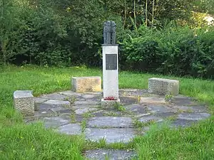
Monument in memory of the victims of the Weyer concentration camp
Wikimedia Commons has media related to Sankt Pantaleon.

This article is issued from Wikipedia. The text is licensed under Creative Commons - Attribution - Sharealike. Additional terms may apply for the media files.