| Mount Discovery | |
|---|---|
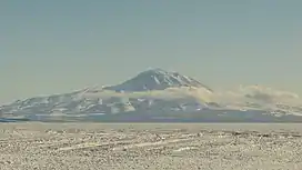 Mt. Discovery seen from Pegasus Field, January 2013 | |
| Highest point | |
| Elevation | 2,681 m (8,796 ft) |
| Prominence | 1,637 m (5,371 ft)[1] |
| Listing | Ultra |
| Coordinates | 78°22′S 165°01′E / 78.367°S 165.017°E[1] |
| Geography | |
 Mount Discovery | |
| Geology | |
| Age of rock | Pliocene-to-Pleistocene[2] |
| Mountain type | Stratovolcano |
| Volcanic belt | McMurdo Volcanic Group |
| Last eruption | 1.87 million years ago[2] |
Mount Discovery is a conspicuous, isolated stratovolcano, lying at the head of McMurdo Sound and east of Koettlitz Glacier, overlooking the NW portion of the Ross Ice Shelf. It forms the center of a three-armed mass of which Brown Peninsula is one extension to the north; Minna Bluff is a second to the east; the third is Mount Morning to the west. Mount Discovery was discovered by the British National Antarctic Expedition (1901–04) and named for their expedition ship Discovery.

Topographic map of the Mount Discovery (1:250,000 scale) from USGS Mount Discovery
See also
References
- 1 2 "Antarctica Ultra-Prominences" Peaklist.org. Retrieved 2012-09-05.
- 1 2 "Mount Discovery". Global Volcanism Program. Smithsonian Institution. Retrieved 2016-04-30.
Sources
- LeMasurier, W. E.; Thomson, J. W., eds. (1990). Volcanoes of the Antarctic Plate and Southern Oceans. American Geophysical Union. p. 512 pp. ISBN 0-87590-172-7.
- "Skiing the Pacific Ring of Fire and Beyond". Amar Andalkar's Ski Mountaineering and Climbing Site. 2007 [1997]. Retrieved 14 January 2005.
- U.S. Geological Survey Geographic Names Information System: Mount Discovery
External links
Wikimedia Commons has media related to Mount Discovery.
This article is issued from Wikipedia. The text is licensed under Creative Commons - Attribution - Sharealike. Additional terms may apply for the media files.