Villiers-Fossard | |
|---|---|
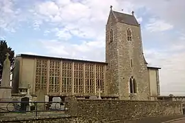 The church of Saint-Pierre | |
Location of Villiers-Fossard | |
 Villiers-Fossard 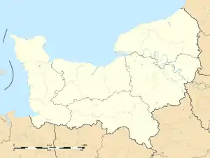 Villiers-Fossard | |
| Coordinates: 49°09′27″N 1°03′31″W / 49.1575°N 1.0586°W | |
| Country | France |
| Region | Normandy |
| Department | Manche |
| Arrondissement | Saint-Lô |
| Canton | Pont-Hébert |
| Intercommunality | Saint-Lô Agglo |
| Government | |
| • Mayor (2020–2026) | Wilfried Guillemet[1] |
| Area 1 | 8.52 km2 (3.29 sq mi) |
| Population | 648 |
| • Density | 76/km2 (200/sq mi) |
| Time zone | UTC+01:00 (CET) |
| • Summer (DST) | UTC+02:00 (CEST) |
| INSEE/Postal code | 50641 /50680 |
| Elevation | 20–133 m (66–436 ft) (avg. 90 m or 300 ft) |
| 1 French Land Register data, which excludes lakes, ponds, glaciers > 1 km2 (0.386 sq mi or 247 acres) and river estuaries. | |
Villiers-Fossard (French pronunciation: [vilje fosaʁ]) is a commune in the Manche department in Normandy in north-western France.
History
During World War II, the town was in the middle of heavy fighting that took place on the 29th of June 1944. Allied forces managed to liberate the town despite suffering heavy casualties - including 151 men, 31 tanks and 12 miscellaneous vehicles.
Heraldry
.svg.png.webp) Arms of Villiers-Fossard |
The arms of Villiers-Fossard are blazoned : Azure, a chevron Or between 3 eagles argent, within a bordure Or.
|
See also
References
- ↑ "Répertoire national des élus: les maires". data.gouv.fr, Plateforme ouverte des données publiques françaises (in French). 2 December 2020.
- ↑ "Populations légales 2021". The National Institute of Statistics and Economic Studies. 28 December 2023.
Wikimedia Commons has media related to Villiers-Fossard.
This article is issued from Wikipedia. The text is licensed under Creative Commons - Attribution - Sharealike. Additional terms may apply for the media files.